ZenithBoard posts every aircraft that crosses my sky on Bluesky; the first article told when and why. This one leaves the posting aside and looks at a single part of each post, the one that changed most over that weekend: the map. It went from a line of dots to a real map in two days, and the interesting part is less the drawing than the decisions around it: whose map, under what licence, what it may show, and who checks it.
Dots were not enough
The first posts, on the Saturday, were the picture of the dot-matrix wall with the aircraft’s track drawn in dots in the right-hand column. It looked right on the tablet and told a follower very little on a phone: a line of dots, with nothing under it.
So the picture changed three times in two days, each time after I had read real posts on a phone and sent the coding agent a note, sometimes a mock-up:
- Day 1: a second look, the split-flap board beside a map. Four maps to choose from.
- Day 2, 0.23.0: the dot-matrix look gets the same map in its right-hand column, in place of the dotted track.
- Day 2, 0.24.0: the dots-only look came out of the choices altogether. A post always carries a map. A Pi still set to the old look is not changed by the update: it posts with a map, and the update says so, with the command to choose another. A changed default must not silently rewrite someone’s settings.
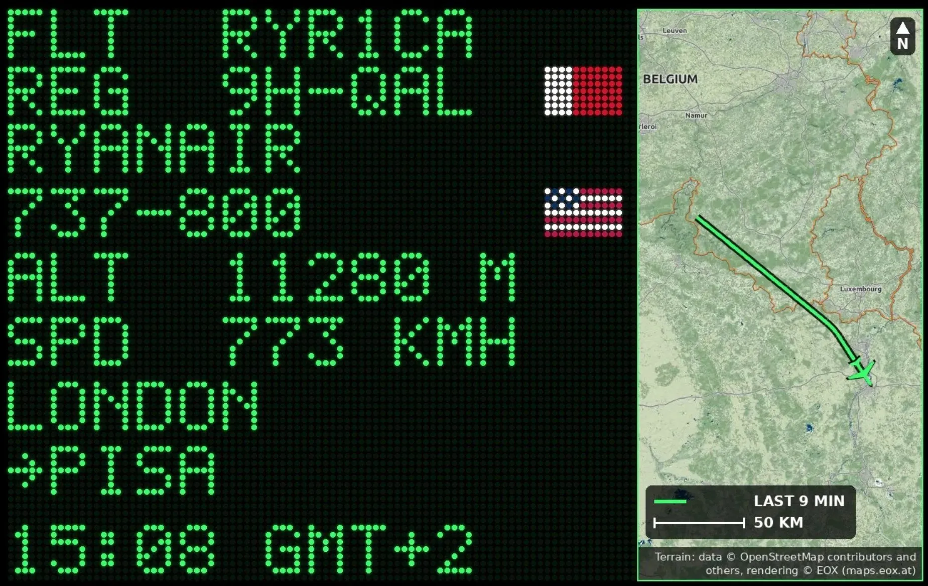
What is on the map
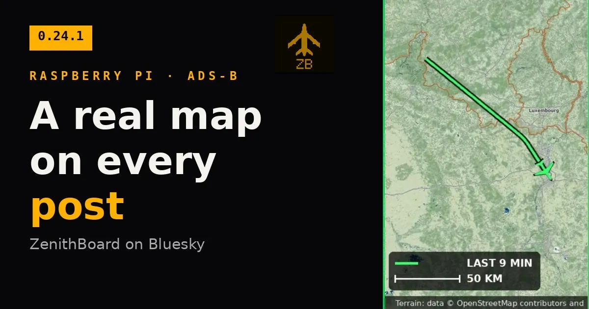
Centred on the aircraft’s track: the track itself and the aircraft in the colour of the picture, with a dark edge so they read on any background; a key (LAST 9 MIN and a scale bar in kilometres or miles); a north arrow; and the credit along the bottom. When the aircraft would land under the key, the view is chosen in the part of the map above it.
Four maps, fixed or in turn:
| Map | What it is |
|---|---|
| normal | EOX’s light relief and main roads, with ZenithBoard’s own names |
| night | the same, dark |
| satellite | Sentinel-2 cloudless by EOX |
| terrain | EOX’s terrain rendering |
Since version 0.24.3 the posts can have their own units: the wall’s, or metric, or feet, knots and miles, on the picture and in the text, for a follower who does not read altitudes in metres.
Where the maps come from
All the tiles come from EOX::Maps, whose layers are free to use with attribution and a link back. The full credit is drawn on the picture and written in its alt text; the post ends with one short line, Map © OpenStreetMap, EOX, each name a link. That is what OpenStreetMap’s attribution guideline accepts, and what EOX asks of an online publication.
I do not use OpenStreetMap’s own tile servers. Their usage policy rules out automated fetching that nobody is watching, which is exactly what a flight board posting by itself does. The satellite layer is for non-commercial use, which is what this is. I checked the tiles in a browser, layer by layer, before the code used them: a supplier’s terms are part of the requirement, not an afterthought.
The Pi asks for the tiles with ZenithBoard’s name, checks that what comes back is an image, caps the size, and keeps them for a month in a small cache (60 MB at most), so the tiles over my sky are fetched once rather than at every post. If no tile comes, the picture shows the track on a dark grid, with no map and no credit: a post never goes out with a credit for a map that is not there.
The towns, named by the Pi
The satellite and terrain maps relied on EOX’s label layer for their place names, and a real post on the Sunday evening showed its limit: one village named in forty kilometres. Since version 0.24.4 ZenithBoard draws the names itself, from a list of the places of 5 000 inhabitants or more shipped with the program (GeoNames, Creative Commons Attribution), the largest first, never over another name, the aircraft, the north arrow or the key. Nothing is looked up on the internet for a name, and the credit on the picture names GeoNames.
The names kept improving after that weekend, each time from a real post. They are drawn over the track, so a track crossing a town no longer cuts letters out of its name. A map that names fewer than three towns adds villages, the largest first, and an empty stretch of map gets its heaviest village. The light and dark maps used to carry OpenStreetMap’s own labels under ours, so a town could be named twice a few pixels apart; they are now built from two EOX layers that carry no names at all. Finally, an optional list made for the region, downloaded once from GeoNames, names places anywhere in the world, not only where populations are well recorded.
While I was at it I asked a question any reader of the post could ask: is the scale bar right? A Transavia at 997 km/h over three minutes flies 50 km; its track measured 48 km against the 10 km bar on the post. Close enough, and now written down.
Varying the posts
Two looks, the dot-matrix wall with a map and the split-flap board, can alternate one post each, and the colour and the map can turn too, so that consecutive posts do not look alike.
The last detail
On the Sunday evening I looked at three real posts: a night map, a satellite map and a terrain map. The maps, the credits, the flags and the key were as intended. The track line was far too thick. Version 0.24.1 draws it at 3 pixels with a dark edge of 6, from 5 and 11. It is the kind of thing no test can find: you have to read your own posts as a follower would.
Next in this series: counting what the wall cannot name or draw. ZenithBoard lives at zenithboard.app, the code is on GitHub, and the Social sharing page of the wiki has every command.
Theme: ZenithBoard. Topics: ZenithBoard, ADS-B, Raspberry Pi, Bluesky.